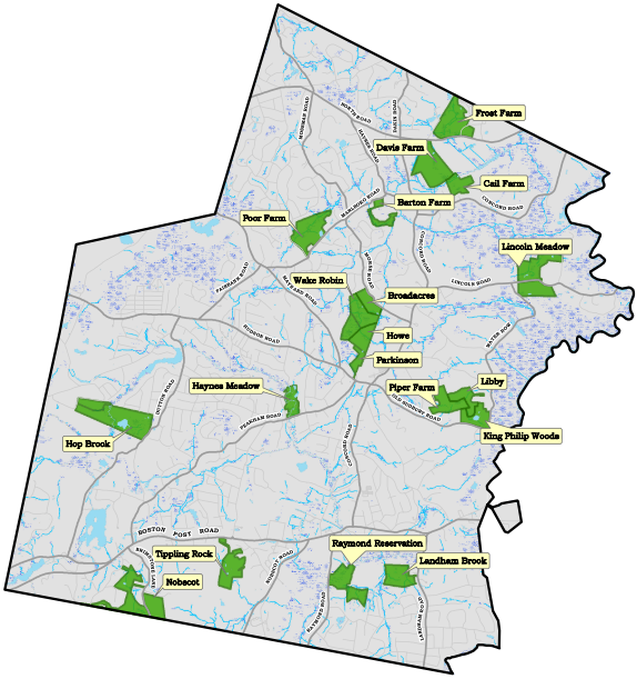
Sudbury Conservation Lands
Town-Owned Conservation Lands
Land Use Policy and Regulations
| Property |
Driving Directions |
Map | Trail Guide | Activities |
|---|---|---|---|---|
| Barton Farm | Directions |  |
||
| Broadacres Farm | Directions |  |
||
| Davis Farm | Directions |  |
||
| Frost Farm | Directions |  |
||
| Haynes Meadow | Directions |  |
||
| Hop Brook Marsh | Directions |  |
||
| King Philip Woods | Directions |  |
||
| Landham Brook Marsh | Directions |  |
||
| Lincoln Meadows | Directions |  |
||
| Nobscot | Directions |  |
||
| Piper Farm | ||||
| Poor Farm Meadow | Directions |  |
||
| Tippling Rock Trail | Directions |  |
Non-Town Owned Lands
| Property | Owner | Map | Activities |
|---|---|---|---|
| Assabet River National Wildlife Refuge |
U.S Fish and Wildlife Service |
||
| Cutting Farm |
Cutting Family |
||
| Gray Reservation | SVT | ||
| Great Meadows National Wildlife Refuge | USFW | ||
| Lyons/Cutler Reservation | SVT | ||
| Marlborough-Sudbury State Forest | MA | ||
| Memorial Forest | SVT | ||
| Nobscot Scout Reservation | Mayflower Council | ||
| Pantry Brook Reservation | MA | ||
| Round Hill | SVT | ||
| Sudbury River |
| Key |
|---|
| USFW = United States Fish and Wildlife Service |
| SVT = Sudbury Valley Trustees |
| MA = State Land |

